head>
Last day on the Hudson River at Astor Point, Barrytown, NY photo Copyright Glen Burger
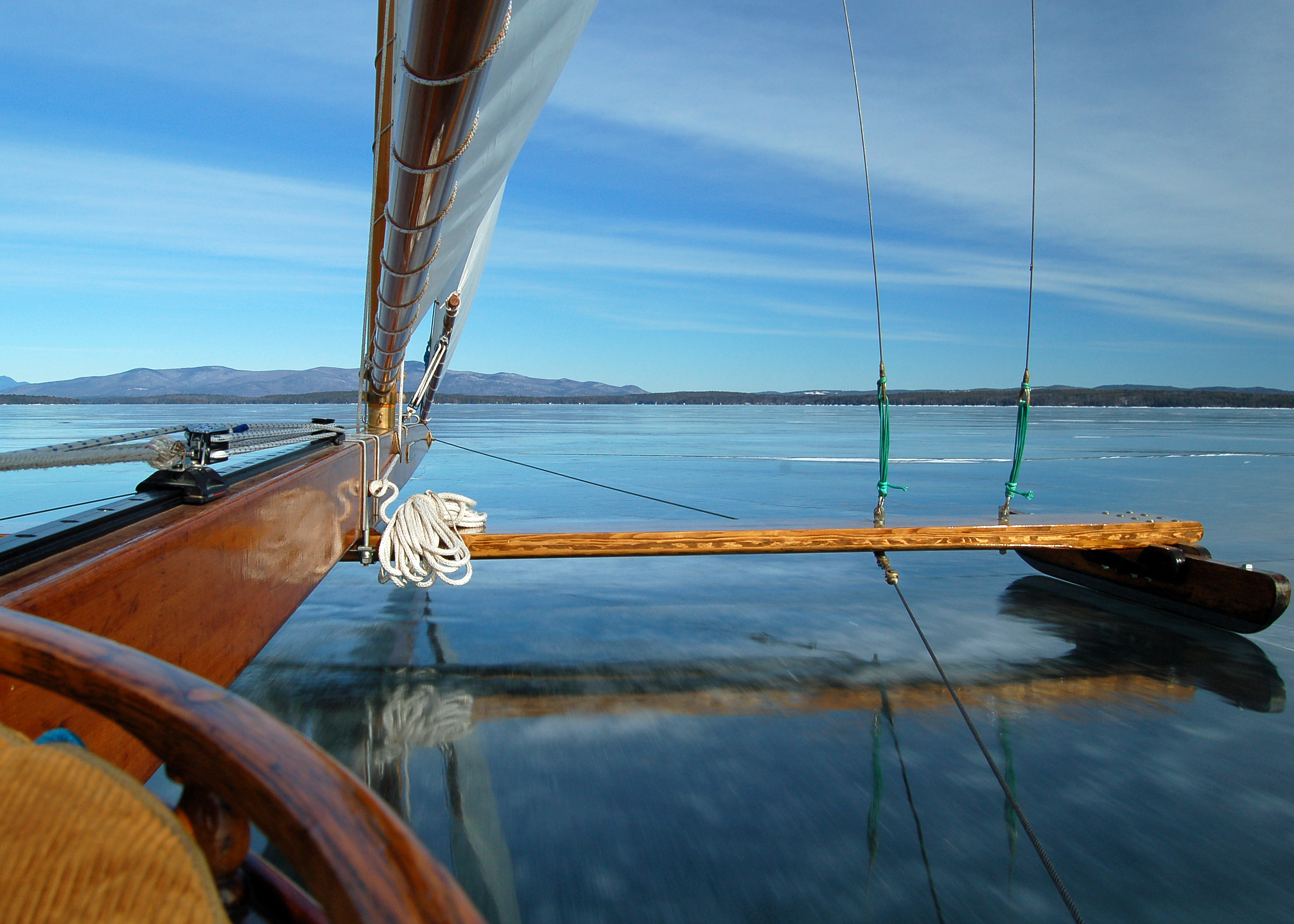
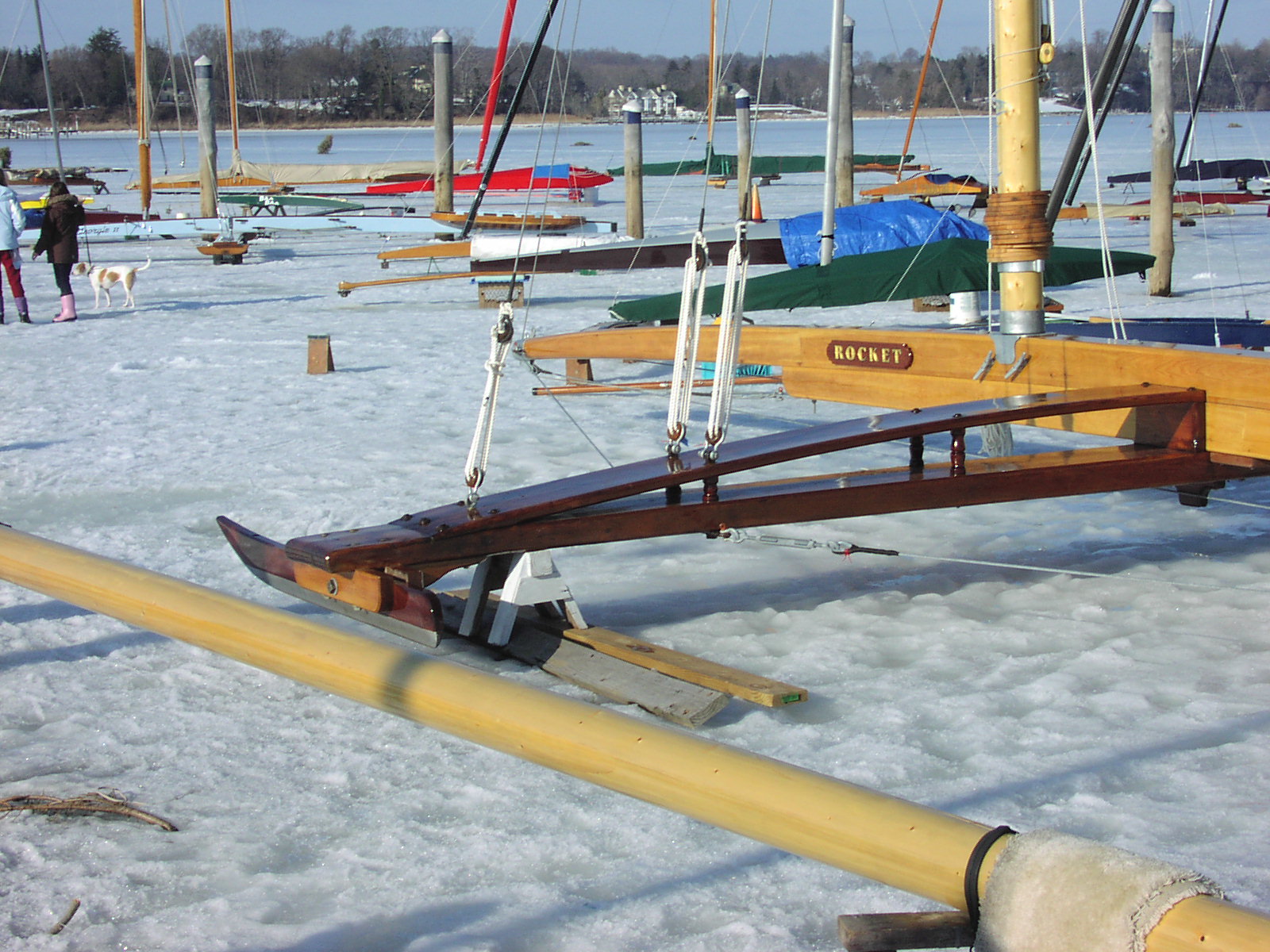
Popular Northeastern Iceboating Destinations This page is written primarily for iceboaters. The listings below catalog some of the more popular iceboating venues here in the Northeast. The tables are ordered first by state or province, then by body of water. Unless noted, the launch coordinates are public access points. I have no personal knowledge of many of these locations, so bear in mind that the data may not be completely accurate, but is based on a best effort to decode the information available to me. Should you find major discrepancies or errors, or would like me to add a new site to the list, please send me the data and I will quickly attend to the update. The basic rules of ice safety apply -- ice is never safe, never go out alone, have your safety gear with you, and always get a scouting report from someone who knows the body of water before you go charging off on what looks to be a perfect sheet of ice. The Hudson River is a tidal estuary, so there is always broken ice and open water at the shoreline as demonstrated in the photo above. Large lakes will develop "reefs" or "pressure cracks" where the ice buckles to relieve the tremendous expansion forces as cold weather grows the sheet. I will continue to develop and update these as time permits, but getting all the little details right and verifying the information has proven to be slow going. Your suggestions and assistance are always appreciated. If you have a GPS, collect the appropriate waypoint data when you go sailing, export it to a file, and email it to me. Send a photo along if you like, and I will add it as appropriate and credit you for your contribution. Launch Coordinates & Street Map Links will bring up a street map. Some of these are served up by MapQuest and others by Google. When I first started this page, Google Maps did not exist and MapQuest seemed to be the best tool available. If you are a fan of Google Maps, you can cut and paste the latitude and longitude into the search bar and it will zoom you right in to the launch site and give you an easy link to get driving directions. Eventually, I will probably point all these links to Google Maps. Driving Directions are easily obtained by clicking on the MapQuest links but they don't zero in on the launch site. They will get you close, but only in a few cases, will they put you on the ice. Topographic Maps will give you the most accurate mapping of the launch sites and the surrounding terrain. One of the neat features of MapTech is that you can change the background map overlay with one click -- if you are dropping in with your J-3 for the afternoon, click on the Aeronautical Chart overlay, and you will have the information you need. GPS Download Files contain GPS waypoint and route information to get to the site or navigate once you are on the ice. You can upload them to most modern GPS receivers using a free transfer utility such as USAPhotoMaps or EasyGPS, or graphically view the data with one of the Google API mapping programs such as Waypoint Visualizer or GPS Visualizer (elevation/speed profiles too!). As the data is developed, the GPX files may evolve to contain known geographic features such as islands or points of interest along the shore as well as the ever changing locations of ice features such as open water, pressure cracks, reefs, or a bottle of Champagne cached on one of the islands of Lake Winnipesaukee awaiting the "Hard Way" sailors. GPX has become the standard data file format for exchanging GPS data and is supported by popular software and hardware from Garmin, Magellan, and Trimble. USAPhotoMaps is a very interesting and useful free program for mapping and getting data to and from your GPS -- it's fast, compact, and downloads aerial photographs and topographic maps while letting you set waypoints and routes by pointing and clicking. Find your favorite launch site, click on the waypoints to get there, and send me the resulting XML file -- I'll do the rest. If you live near one of these locations and/or would like to serve as a contact person for a particular venue, please email me with your information and I will add it to this work in progress. Interesting photos are always appreciated. |
| Name | Launch Coordinates &
Street Map Link
Contact person |
Driving Directions | Topographic Map | GPS Download File (GPX) |
| Bantam Lake 117 North Shore Drive Bantam CT 06750 |
41.712603 -73.227403 | MapTech | BANTAM.GPX | |
| Candlewood Lake Lattins Cove Forty Acres Road Danbury CT |
||||
| Candlewood Lake Squantz Pond State Park New Fairfield CT |
||||
| Lake Pocotopaug Sears Park East Hampton CT 06424 |
Bob Kilpatrick 860-256-7527
|
MapQuest | MapTech | POCOTOPA.GPX |
| Pauchaug Pond
Griswold CT |
||||
| Rogers Lake Haines Park Laysville Center CT 06371 |
41.34915 -72.29843 | MapQuest | MapTech | ROGERS.GPX |
Maine
photo Copyright John Sperr
| Name | Launch Coordinates & Street Map Link
Contact person |
Driving Directions | Topographic Map | GPS Download File (GPX) |
Chickawaukie Pond |
MapQuest | MapTech | CHICKA.GPX | |
| Damariscotta Lake Damariscotta State Park Jefferson ME 04348 |
MapTech | DAMARIS.GPX | ||
| Eagle Lake
Fort Kent ME |
||||
| Great Pond
Belgrade ME 04917 |
||||
| Kennebunk Pond
Lyman ME |
||||
| Long Pond Route 46 Bucksport ME 04416 |
||||
| Messalonskee Lake
Oakland ME |
||||
| Moosehead Lake
Greenville ME |
||||
| Plymouth Pond Route 7 Plymouth ME 04969 |
44.761079 -69.203355 |
MapQuest |
MapTech |
PLYMTHPD.GPX |
| Saponac Lake
Burlington ME |
||||
| Sebago Lake Route 302 Raymond ME 04071 |
43.889248 -70.474238 | MapTech | RAYMOND.GPX | |
| Sebago Lake Lower Bay -- "Pump House" Northeast Road Ext. Sebago Lake (Standish) ME 04084 |
43.7636 -70.5226 | MapQuest | ||
| Taylor Pond
Auburn ME |
||||
| Toddy Pond Route 1 East Orland ME 04413 |
44.565922 -68.672074 | MapQuest | MapTech | TODDY.GPX |
|
Walker Pond |
44.319795 -68.701939 Private Property -- No Public Access Kevin Grindle 207-348-2749 Home 207-266-0412 Cell |
MapQuest | MapTech | WALKER.GPX |
| Name | Launch Coordinates & Street Map Link
Contact person |
Driving Directions | Topographic Map | GPS Download File (GPX) |
| Cedar Lake
Sturbridge MA |
||||
| Lake Quinsigamond Regatta Point State Park Millbury MA |
||||
Long Pond (Cape Cod) |
||||
|
Long Pond (Freetown / Lakeville) |
||||
Long Pond (Freetown / Lakeville) |
||||
| Norton Reservoir Juniper Road Norton MA |
41.982022 -71.188088 primary
41.989792 -71.195432 secondary |
MapQuest |
|
NORTON.GPX |
| Quaboag Pond Quaboag Street / Shore Road Brookfield MA |
42.203325 -72.063073 | MapQuest | MapTech | QUABOAG.GPX |
| South Watuppa Pond Jefferson Street Extension Fall River MA |
41.673.717 -71.140548 | MapQuest | MapTech | WATUPPA.GPX |
| Webster Lake 230 Thompson Road Webster MA 01570 |
Lake Chaubunagungamaug | MapTech | WEBSTER.GPX | |
| West Monponsett Lake
Halifax MA |
| Name | Launch Coordinates & Street Map Link
Contact person |
Driving Directions | Topographic Map | GPS Download File (GPX) |
| Canobie Lake
|
||||
| Dublin Lake
Dublin NH |
||||
| Eastman Lake
|
||||
| Kanasatka Lake
|
||||
| Mascoma Lake
Enfield NH |
||||
| Massabesic Lake Route 121 Auburn, NH 03032 |
42.999708 -71.345517 | MapQuest | MapTech | MASSABESIC.GPX |
| Otter Pond
New London NH |
||||
| Potanipo Pond
Brookline NH |
||||
| Squam Lake Squam Channel Route 113 at Dirt Road Holderness NH 03245 |
||||
| Lake Sunapee Mt. Sunapee State Park Beach 99 Beach Road Mount Sunapee NH 03255 |
43.342907 -72.061907 | MapTech | SUNAPEE.GPX | |
| Lake Wentworth Wentworth State Park Route 109 Wolfeboro NH 03894 |
43.612400 -71.146133 | WENTWRTH.GPX | ||
| Lake Winnipesaukee Brewster Beach Wolfeboro NH 03894 |
43.577646 -71.209636 | BREWSTER.GPX | ||
| Lake Winnipesaukee 50 Leavitt Park Road Meredith NH 03253 |
43.681198 -71.453978 | MEREDITH.GPX | ||
Lake Winnipesaukee |
43.5755 -71.3554 |
MapQuest |
|
photo Copyright John Sperr
| Name | Launch Coordinates & Street Map Link
Contact person |
Driving Directions | Topographic Map | GPS Download File (GPX) |
| Budd Lake
Budd Lake NJ 07828 |
40.86308 -74.75081 | MapQuest | MapTech | |
| Greenwood Lake
|
MapQuest | MapTech | ||
| Lake Hopatcong State Park Lake Hopatcong NJ 08733 |
MapQuest | MapTech | ||
| Lake Musconetcong
Netcong NJ 07857 |
MapQuest | MapTech | ||
| Navesink River Union Street Red Bank NJ 07701 |
NSIBYC -- Private Property
732 747-9845 Club House 732 747-5665 Ice Line |
NSIBYC.GPX | ||
| Shrewsbury River
|

photo Copyright Glen Burger
| Name | Launch Coordinates & Street Map Link
Contact person |
Driving Directions | Topographic Map | GPS Download File (GPX) |
Canadarago Lake |
||||
| Chippewa Bay Chippewa Bay NY 13623 |
315 323-3618 cell 315 324-6026 work |
|||
| Great South Bay, Long Island Bellport Lane Bellport NY 11713 |
||||
| Hallock's Bay (Long Beach Bay) Narrow River Road Orient Point Southold NY 11971 |
MapQuest | MapTech | ||
| Hudson River DEC Fishing Access Area Athens NY 12015 |
||||
| Hudson River Athens Village Park Athens NY 12015 |
||||
| Hudson River The Anchorage North Germantown NY 12526 |
42.158372 -73.886754 | MapQuest | MapTech | ROKEBY.GPX |
| Hudson River Cheviot Landing Cheviot NY 12526 |
42.125907 -73.904841 | MapQuest | MapTech | ROKEBY.GPX |
| Hudson River Glasco Town Park Glasco NY 12432 |
42.040653 -73.941393 | ROKEBY.GPX | ||
| Hudson River South Tivoli Bay Barrytown NY 12507 |
42.008319 -73.927631
|
MapQuest | MapTech | ROKEBY.GPX |
| Hudson River Astor Point Barrytown NY 12507 |
Private Property Ricky Aldrich 845-758-8693 |
|||
| Hudson River Long Dock Rhinecliff NY 12574 |
41.9312 -73.9460 | ROKEBY.GPX | ||
| Hudson River Town Dock Rhinecliff NY 12574 |
41.9200 -73.9531 | ROKEBY.GPX | ||
Keuka Lake |
||||
| Lake Mahopac Putnam County Mahopac NY 10541 |
Private Property | MapQuest | MAHOPAC.GPX | |
| Lake Ronkonkoma
Lake Ronkonkoma NY |
||||
| Nicholl Bay / Connequot River
|
||||
| Otsego Lake
Cooperstown NY |
||||
| Peach Lake
|
||||
| Round Lake Route 9 Round Lake NY 12151 |
42.937148 -73.790421 | MapQuest | MapTech | ROUND.GPX |
| Saratoga Lake South Shore Marina Saratoga Lake NY |
Closed -- Property Sold | SRBM.NET | MapTech | SARATOGA.GPX |
| Schroon Lake
Schroon Lake NY |
||||
| Sodus Bay South Shore Road Sodus Point NY 14555 |
43.258533 -76.988730
Sodus Bay Ice Boat Club 585-234-2030 |
MapQuest | SODUS.GPX | |
| White Lake State Boat Launch, Route 55 Bethel NY 12786 |
41.685786 -74.831682 | MapQuest | ||
| Youngs Lake
Richfield Springs NY |
| Name | Launch Coordinates & Street Map Link
Contact person |
Driving Directions | Topographic Map | GPS Download File (GPX) |
| Pecks Pond Route 402 Pecks Pond PA 18328 |
41.284200 -75.081000 | MapQuest | PECKS.GPX | |
| Lake Wallenpaupack Wilsonville Boat Launch Hawley PA 18428 |
41.449306 -75.182536 | MapQuest | WALLEN.GPX | |
| Presque Isle Bay Erie Yacht Club Erie PA |
42.121134 -80.129912 | MapQuest | MapTech | ERIE.GPX |
| Presque Isle Bay Presque Isle State Park Erie PA |
42.114393 -80.153423
814-833-7424 |
MapQuest | MapTech | ERIE.GPX |
| Name | Launch Coordinates & Street Map Link
Contact person |
Driving Directions | Topographic Map | GPS Download File (GPX) |
| Lac Saint-Louis Rue Lakeshore Beaconsfield QC |
45.4145 -73.8950 | MapQuest |
|
STLOUIS.GPX |
| Name | Launch Coordinates & Street Map Link
Contact person |
Driving Directions | Topographic Map | GPS Download File (GPX) |
| Ninigret Pond East Beach Road Charleston RI |
41.344655 -71.690523 | MapQuest | MapTech | NINIGRET.GPX |

photo Copyright John Sperr
| Name | Launch Coordinates & Street Map Link
Contact person |
Driving Directions | Topographic Map | GPS Download File (GPX) |
Lake Champlain |
||||
| Lake Champlain Button Bay Shelburne VT |
||||
Lake Champlain |
||||
| Lake Champlain Malletts Bay Colchester VT 05446 |
||||
| Lake Morey
Fairlee VT |
||||
| Shelburne Pond Irish Hill Road Shelburne VT 05482 |
44.376700 -73.160700 | MapQuest | MapTech | SHELBURNE.GPX |

photo Copyright John Sperr